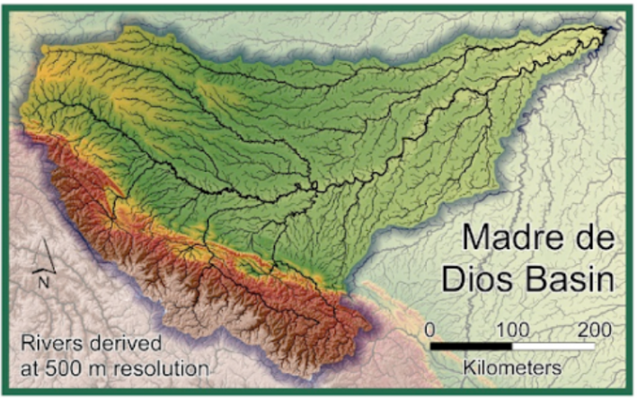
Land surface water routing describes how water flows on hillslopes and through river channels on the Earth’s surface. At a very high level, these processes close the water cycle on Earth and therefore are also required in climate models. Rivers provide freshwater to the ocean at river deltas, play a pivotal role in local wild environments, supply communities with water, and present flood risks during periods of high flow. Modeling river flow and other surface routing processes is an important task for any Earth system model. Many river models used in land surface models are rooted in the physical laws…
Read More

Blog

by Tobias Bischoff and Katherine Deck Climate simulations play a crucial role in understanding and predicting climate change scenarios. However, the spatial resolution that simulations can be carried out with is often limited by computational resources to around ~50-250 km in the horizontal. This leads to a lack of high-resolution detail; moreover, since small-scale dynamical processes can influence behavior on larger scales, coarse resolution simulations can additionally be biased compared to a high-resolution “truth”. For example, simulations run at coarse resolutions fail to accurately capture important phenomena such as convective precipitation, tropical cyclone dynamics, and local effects from topography and…
Read More

Weather disasters are extremely damaging to humans (e.g., severe storms, heat waves, and flooding), our livelihoods (e.g., drought and wildfire), and to the environment (e.g., coral bleaching via marine heatwaves). Although heavy storms, severe drought, and prolonged heat waves are rare, they account for the majority of the resulting negative impacts. For individuals, governments, and businesses to be able to best prepare for these events, their frequency and severity need to be quantified accurately. A major challenge, however, is that we need to form our estimates using a limited amount of historical data and simulations, where extreme events appear rarely.…
Read More